Greece
GSI reroute claims raise geographic questions as Greece says original plan stands
Greece says it knows of no redesign of the Great Sea Interconnector. Public descriptions of the Crete–Cyprus cable raise questions about claims of a detour around Fethiye–Kaş.

Claims that Greece and France are considering a slight change to the Great Sea Interconnector to avoid Turkey’s Fethiye–Kaş marine park face a basic geographic question: the publicly described first stage runs between Crete and Cyprus, substantially to the south of the park near Turkey’s southwestern coast.
On September 28, Greek government spokesperson Pavlos Marinakis said he was unaware of any redesign. The information available to him, he said, was that the project would proceed on the basis of its original plan as described by the responsible ministers. His response addressed reports suggesting a revised route, rather than announcing a new route himself.
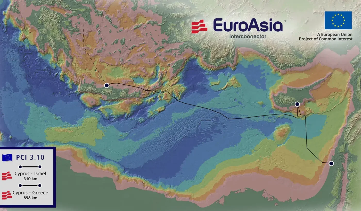
The project’s own description identifies its first stage as an 898-kilometer submarine connection between Crete and Cyprus. It says this section has received €657 million from the European Union’s Connecting Europe Facility. Israel is part of the wider Greece–Cyprus–Israel vision, but the Crete–Cyprus link is the section currently being developed.
The geographic issue
Fethiye and Kaş lie on the Turkish coast north of Kastellorizo. The Crete–Cyprus connection, as described in public project material, heads east from Crete toward Cyprus across the eastern Mediterranean. On those publicly available descriptions, a claim that the established principal corridor must be diverted around the Fethiye–Kaş park requires a more precise explanation of where the alleged intersection occurs.
An earlier EuroAsia Interconnector map illustrates the broad corridor from Crete to Cyprus and on to Israel. That map predates the current Great Sea Interconnector implementation and is not a detailed, approved seabed survey. It can show the broad geography but cannot establish the precise line that a cable-laying vessel will follow.
The issue raised by the original Greek reporting is therefore specific: a proposed political reroute to avoid the marine park has not been substantiated by the public project description or by the government’s September 28 response. Small technical adjustments for seabed conditions and installation are a separate possibility, and the available statements do not rule them in or out.
There is a wider Greek concern over Turkish maritime claims and the surveys needed for the project, particularly in waters associated with the corridor south of Kasos and Karpathos. That concern does not by itself establish that the cable’s Crete–Cyprus section would cross the Fethiye–Kaş park. The distinction matters when assessing whether a reported route change reflects an actual project decision.
For now, the Greek government’s stated position is that it knows of no redesign. The official project description still presents the Crete–Cyprus section as the first stage, while detailed survey and installation decisions remain matters for the project’s implementing bodies.