Asia-Pacific
Puncak Jaya: NASA Landsat images record the end of the glaciers in New Guinea
NASA satellite images show the ice on top of Puncak Jaya in New Guinea has shrunk to scattered fragments too small to move as glaciers, from about 4.31 square kilometres in 1988 to 0.09 in 2025.

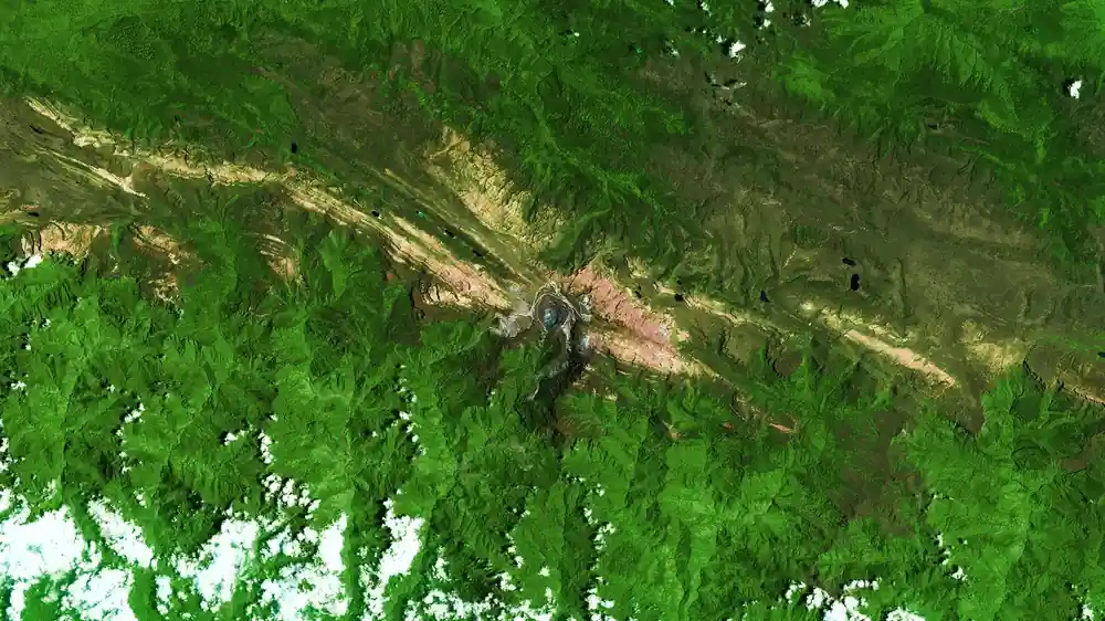
The ice at the top of Puncak Jaya in New Guinea has shrunk into scattered patches, too small to move like glaciers, according to satellite images released by NASA on Monday, November 16. NASA’s Earth Observatory compared 1988 and 2026 images from the Landsat satellites to show how far the ice has retreated.
Puncak Jaya lies in the Sudirman Range on the island of New Guinea and is one of the few places near the equator where ice existed all year round. It sits next to the largest expanse of warm ocean on the planet, near the warmest conditions in which ice can survive. Scientists regard these glaciers as early warning indicators for high altitudes (“canaries in the coal mine”), like other tropical ice: the ice fields of Kilimanjaro in Tanzania, the Quelccaya ice cap in Peru and the remnants of the Humboldt glacier in Venezuela.
From 4.31 to 0.09 square kilometres
The images come from Landsat 5, for the shot of November 3, 1988, and from Landsat 9, for the shot of October 19, 2026. In the false-colour images ice appears light blue and bare rock brown. In 1988 ice covered several of the highest ridges, while in 2026 only a few small fragments are left.
The figures were given by Donaldi Permana, a climatologist at Indonesia’s Meteorology, Climatology and Geophysics Agency (BMKG). In 1988 the glaciers covered about 4.31 square kilometres. By September 2025, satellite and aerial data showed that only 0.09 square kilometres remained, an area equal to about a dozen football pitches and around 2% of the 1988 extent. An aerial survey planned for December will give an estimate of how much ice there is in 2026.
The ice has also become thinner. At the main monitoring site, the East Northwall Firn snowfield, the thickness fell from 32 metres in 2010 to 4 metres in 2023, and in November 2024 the ice there had disappeared, Permana said.
A self-reinforcing process
The process feeds itself. As glaciers thin they break into pieces, and each new fragment has more exposed edges from which the ice melts. Snow still falls, but it does not persist on the bare rock to form new ice. “It’s like a house of cards,” said Chris Shuman, a retired glaciologist at the University of Maryland. “Once the process starts, there’s no going back.”
To count as a glacier, ice generally has to be thick enough to flow downhill under its own weight. The ice of Puncak Jaya has broken into such small, stationary sections that it no longer flows. “Their functional life as active glaciers has essentially ended,” Permana said.
El Niño
Recent satellite studies suggest that the main areas of glacial ice may disappear around 2030. BMKG’s estimates indicate it could happen much sooner, accelerated by the current El Niño. El Niño years have hit these glaciers especially hard. When the air warms, the 0 °C isotherm rises above the summit and precipitation falls as rain instead of snow. Less fresh white snow remains to reflect sunlight and protect the ice, and the darker surfaces left exposed absorb more heat and melt faster. In the 2015-2016 El Niño the ice thinned about five times faster than usual, losing about 5.3 metres of thickness in a year, and in 2023-2024 it lost 2 to 4 metres a year.
The images were processed by Lauren Dauphin using Landsat data from the US Geological Survey (USGS). The original report by Kathryn Hansen is available on NASA’s page “The Last Ice on Puncak Jaya”.